Product Description.
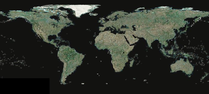
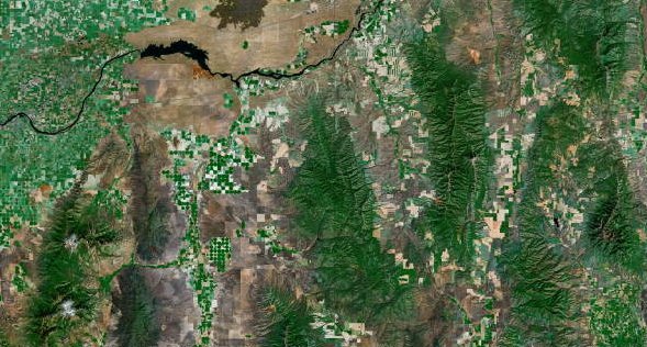
TruEarth 15-meter imagery is the baseline for global, natural-color, Earth imagery. A complete, 3.6 TB, global mid-resolution dataset, TruEarth 15-meter imagery is ideal for web mapping, simulation, visualization and GIS applications. TruEarth 15-meter imagery provides complete, best-available, substantially cloud-free, global coverage (except Antarctica) of the Earth at 15-meters-per-pixel resolution. We provide TruEarth imagery as 23,135 1° x 1° drop-in JPEG2000 geo-referenced image tiles, each with 8,176 x 8,176 pixels. (Optionally available in GeoTIFF format)
You’ve seen TruEarth on Google Earth and Google Maps… discover why TruEarth is the preferred basemap imagery for some of the most visible web mapping services; simulation applications; and broadcast, print and film. TruEarth imagery is also playing an important role in next-generation Synthetic Vision aviation flight displays.
TruEarth 15-meter imagery licenses are available in either an End-user Site and Company/Agency type or OEM Integrator type. End-user licenses allow use of the imagery for essentially any creative or technical purpose other than resale or distribution of the product. OEM licenses allow embedded use and distribution of the imagery in physical devices, software applications and web applications.
Features.
TruEarth 15-meter imagery comes as a standard off-the-shelf product with these features:
- Pure TruEarth Color
- Uncompressed NASA Source Data Lineage
- Global Coverage (less Antarctica)
- Seamless Drop-in 1° x 1° uncompressed JPEG2000 Image Tiles
- Standard WGS84 Geographic Projection
- Best-available Landsat 7 ETM+ Source Data (c.2000)
- Globally Accurate to <50 meters RMSE
- No-nonsense Licensing Terms
Applications.
As a universal, accurate basemap, TruEarth 15-meter imagery is ready to support your application. TruEarth 15-meter imagery is ideal for:
- Web Mapping Services
- Simulation
- IFE Moving Maps
- GIS
- Broadcast News and Weather Systems
- Visual Effects/Animation
- Museum-grade Displays and Print Media
Specifications.
TruEarth 15-meter imagery adheres to the most stringent orthorectified satellite imagery standards.
|
TruEarth Global 15-meter Natural-color Imagery |
|
| Coverage area: | Nominal global coverage, less Antarctica |
| Projection: | WGS84 Geographic (Equi-rectangular) |
| Resolution: | 8,176 pixels per degree / 0.5 arcsecond per pixel / 15 meters per pixel (nominal) |
| Accuracy: | 50 meters RMSE net (nominal) |
| Source imagery: | Uncompressed orthorectified Landsat 7 ETM+ imagery (c.2000) |
| Cloud cover: | Generally <10% cloud coverage — some areas such as equatorial and island regions contain higher cloud-cover characteristics |
| Color balance: | Standard TruEarth natural-color balance |
| Imagery structure: | 23,135 seamless 1° x 1° tiles |
| Total dataset size: | 250GB (3.6TB equiv. uncompressed) |
| Imagery delivery file format: | JPEG2000 geo-referenced image format |
| Delivery: | Off the shelf |
Note: We produced TruEarth 15-meter imagery using pure uncompressed Landsat 7 source data provided to TerraMetrics by NASA Stennis Space Center.
Pricing & Availability.
TruEarth 15-meter imagery is available in global coverage only, delivered in a 10:1 compressed JPEG2000 (.JP2) file format (optionally uncompressed GeoTIFF) and pricing is based on the desired license type.
TruEarth 15-meter imagery is available off-the-shelf for quick delivery.
|
Global Coverage Area |
Pricing (U.S. $) by License Type |
||
| OEM/Integrator | Company/Agency | Multi-Workstation Site | |
| 10:1 Compressed (JP2): | $6,960 | $4,160 | $2,790 |
| Uncompressed (GeoTiff): | $19,900 | $11,900 | $7,990 |
TerraMetrics provides special discounted pricing for educational activities. Let us know about your project and we will work with you to get the TruEarth imagery that you need.
No-Nonsense Licenses.
TruEarth 15-meter imagery licenses are available in either an End-user or OEM Integrator type. End-user licenses allow using the imagery for the creation of derivative works, such as film, video, print, etc. OEM licenses allow embedded use and distribution of the imagery in physical devices, software applications and web applications. Our licensing terms are simple and to the point… no-nonsense, minimally constrained use of TruEarth imagery. The general terms of each license type follow below.
In all cases, TerraMetrics grants to the Licensee a limited, perpetual, non-exclusive license to use the provided Licensed Product under the following license terms:
- Multiple-workstation End-user Site License.
The Licensee may make copies and use the Licensed Product on any number of workstations at a single licensed physical location; the Licensee, including contractors or consultants working for the Licensee at the licensed site, may use the Licensed Product in the production of unlimited derivative products of any media type, including film, broadcast, video, DVD, HD, print, or anything else; and the Licensee may distribute or publish derivative products created using the Licensed Product, for commercial gain or not, as long as the derivative product does not contain a reusable form of the Licensed Product. Derivative product distribution rights are worldwide and in perpetuity. - Company/Agency-wide End-user License.
The Licensee may make copies and use the Licensed Product on any number of workstations within a single company or government agency across multiple physical locations; the Licensee, including contractors or consultants working for the Licensee at the licensed site, may use the Licensed Product in the production of unlimited derivative products of any media type, including film, broadcast, video, DVD, HD, print, or anything else; and the Licensee may distribute or publish derivative products created using the Licensed Product, for commercial gain or not, as long as the derivative product does not contain a reusable form of the Licensed Product. Derivative product distribution rights are worldwide and in perpetuity. - OEM (Integrator/Unlimited) License.
The Licensee may embed protected copies of the Licensed Product into physical devices, software applications or Internet web services manufactured by the Licensee for external distribution to third parties, for commercial gain or not. The embedded form of the Licensed Product data must be protected by use of a Licensee-proprietary data format that prevents extraction or reconstruction of the Licensed Product.
Questions on TruEarth Licensing?
We strive to present TruEarth imagery licensing in simple language with broad use rights. If you need more information or have questions on TruEarth licensing, please visit the Contact Us page.