Who We Are
TerraMetrics provides cost-effective satellite imagery, 3D terrain datasets and 3D terrain-rendering software and tools to the computer visualization, simulation, mapping and animation markets. We offer TruEarth global, natural-color satellite imagery, and provide geo-spatial tools research and development capabilities.
Global Satellite Imagery
Our commercial, off-the-shelf TruEarth product lines provide remarkable, natural-color Earth imagery in a range of resolutions. The first product line we introduced, TruEarth 1km, was the first cloud-free, 1km-per-pixel imagery of its kind to incorporate actual landcover-based coloring rather than a normalized vegetation index approach.
Our current TruEarth 15-meter global satellite imagery is the established baseline for globally consistent, natural-color Earth imagery. TruEarth 15-meter products meet standardized mapping accuracy requirements, operate efficiently within the server-side and rendering environments and provide strong visual appeal to the user. Google launched their Google Earth and Maps web mapping products using our TruEarth 15-meter dataset.
3D Terrain Rendering
TerraMetrics has developed a range of flight-based, 3D terrain storage and rendering technologies. Our legacy TerraBlocks™ technology first established a new standard for mission-critical, embedded 3D terrain-rendering applications that support aircraft primary flight display requirements. Our current-generation nScape renderer takes performance to the next level. Its innovative approach provides unprecedented high-precision terrain rendering along with a consistent frame rate and lightweight platform requirements.
Our Expertise
TerraMetrics produces TruEarth satellite imagery and terrain products using in-house-developed and third-party software tools. As a result, we have developed many proprietary terrain and image processing tools and techniques. We intimately understand terrain processing and rendering techniques and strategies, and have received worldwide recognition from our customers for providing high-quality products and exceptional support. Our staff has extensive background in the methods and algorithms of digital image processing; mapping and geographical data handling; and 3D computer graphics.
Our Customers
A leader in developing accurate global imagery, TerraMetrics provides TruEarth image data products and 3D terrain-rendering technologies to a broad customer base including U.S. Department of Defense agencies, the National Aeronautics and Space Administration (NASA), primary aerospace and defense, geo-intelligence, simulation, major web mapping applications, U.S. and international television news outlets, feature film and television productions and computer graphics animators.
Where We Are
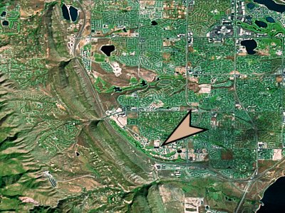
TerraMetrics is located in Littleton, Colorado, USA, right up against the Rocky Mountain Front Range. Our physical location on the Earth’s surface is: N39.5685° latitude, W105.1148° longitude and 1,745 meters elevation, shown here in our global TruEarth 15-meter imagery:
